You Dropped Something...
In 1961, the USAF accidentally dropped a couple live nukes in the North Carolina countryside. One of the bombs was found casually standing nose-down beside a tree, its fall having been slowed to a leisurely pace by a parachute. The other bomb was not so lucky.
The second bomb plummeted to earth at a not-so-leisurely 693 miles per hour. The tail of the bomb was found 20 feet below ground, the explody lump of uranium and plutonium ended up much deeper. How much deeper? In 2005 University of North Carolina at Chapel Hill determined it to be buried at round 180 feet. Wait, 2005? It's still down there?!
It's Still Down There
Yep. It's still down there. In a sort of Oak Island Money Pit twist of events, the Army Corps of Engineers couldn't remove the ground water fast enough to successfully dig the warhead out. So rather than keep trying to dig the thing out, they filled the hole back in and gave the owners of the property $1000 for a perpetual easement on their land.
The easement is for a perfectly circular chunk of land, 400 feet in diameter. It restricts the owner of the land from digging below a depth of 5 feet from the surface, prohibits building anything, and prohibits drilling wells. It also grants the government access to inspect the land.
Where is it?
The Wikipedia article on the incident reports the location of the centre of the easement as 35°29'34.95"N, 77°51'33.34"W, with the source cited as this 2010 article. That article very extensively quotes this book, which has this recollection by Air Force officer Joel Dobson:
1) Start at the center of the bridge over Nahunta Swamp stream on NC State Route 1534 (Big Daddy’s Road). The bridge is located about 2 miles southwest of Faro, NC. Then go 2,135 feet northeasterly (back toward Faro) on the road. That will bring you to: 2). The common corner of the Davis and Edmundson land. There is nothing to mark that spot, it was just the nearest property line at the time. That’s apparently essential for surveyors. 3). From that point, continue northeast for another 835.6 feet along the centerline of the road, (49 degrees magnetic)...Look to your left, at about 90° relative to the road. You will be looking northwest on a magnetic heading of 320 degrees (or, in the wording of surveyors: N 40 degrees 32’ W)...The GPS coordinates...are N 35° 29.525 W 77° 51.50. In the survey format of Degrees/Minutes/Seconds, the coordinates would be 35° 29' 31.5" N 77° 51' 30" W.
Do you see the problem? The coordinates given in Dobson's recollection do not match the coordinates given in the Wikipedia article. Dobson's coordinates are in the middle of Big Daddy’s Road. The source of the discrepancy is easy to discover. In the Talk page comments, one will find this note:
I have amended the location to show the centre point of the "circular easement", calculated using the details here: http://www.restorationsystems.com/uncategorized/whoops-atomic-bomb-dropped-in-goldsboro-nc-swamp-neuse-huc-02/ and the original easement documentation here: http://www.ibiblio.org/bomb/ease.html [-anonymous editor]
But there's still a problem: they're still wrong.
Let's do Better
Let's look at the actual language of the easement:
ALL of that area in the form of a circle, having a radius of 200 feet, with the center point of radius located through the following traverse: From a common corner to the lands of heirs of Charles T. Davis, Sr. and land of J. A. Edmundson, located on the centerline of N. C. State Road 1534 and approximately 2,135 feet northeasterly from the centerline of Nahunta Swamp; thence along the centerline of N. C. State Road 1534, N 49 degrees 28' E, 835.56 feet; thence leaving the centerline of N.C. State Road 1534, N 40 degrees 32' W, 420 feet to the center point of radius, and containing 2.88 acres, more or less.
It seems any solution based on the centerline of Nahunta Swamp is fraught with error. How do you accurately determine the center of a swamp? Dobson thinks it's the bridge, but the easement makes no mention of the bridge. How about instead of using the centreline of a nebulous body of water, we use the "common corner to the lands of heirs of Charles T. Davis, Sr. and land of J. A. Edmundson"? It turns out that with the help of the Wayne County GIS system, that corner is really easy to locate, and the rest of the instructions of the easement can be followed from there:
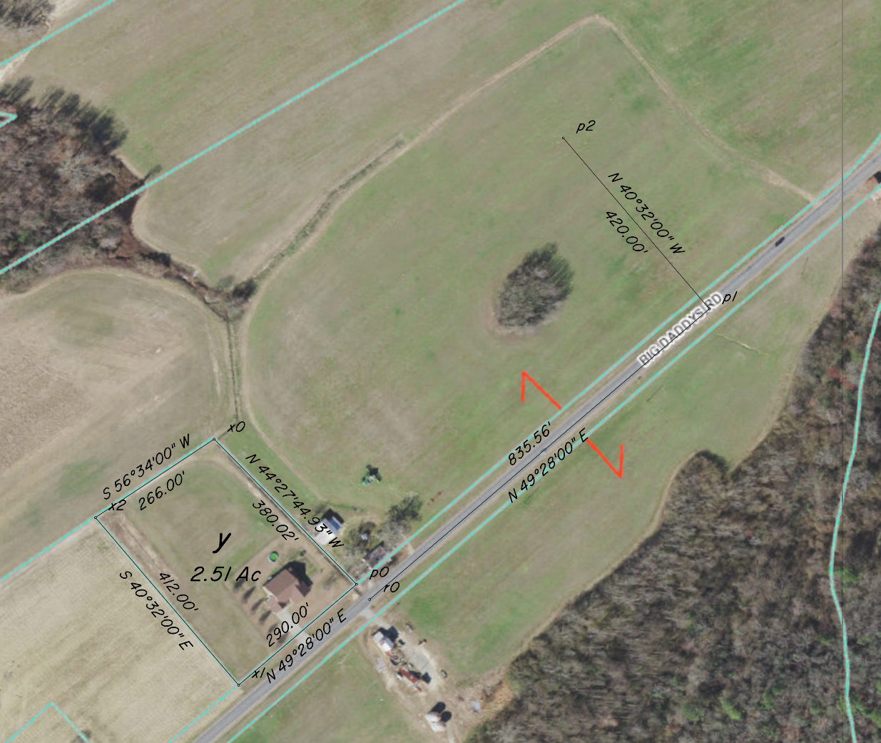
This image was produced by merging a screenshot of the GIS system with the output of my own tool that I created to plot traverses. The GIS system uses an ambiguous scale indication that completely ignores screen resolution, so I ended up using the dimensions of Edmundson's lot (points p0, x0, x1, x2) to establish a scale datum. p0 marks the shared corner of Edmundson's lot and Davis' lot. The traverse as laid out in the deed starts at point r0, which is offset 37.5 feet southeast from p0 perpendicular to the lot line, to establish a centreline on what appears to be a 75 foot road allowance. p1 marks the 90° turning point in the middle of the road, and p2 marks the centre of the 400 foot diameter easement, with approximate coordinates of 35°29'37.07"N 77°51'30.56"W
Wait, approximate coordinates? Well, the Wayne County GIS system uses a local coordinate system, and I couldn't be bothered with converting back and forth, so I instead measured distances to the point using my not-CAD system, used those distances in google earth to draw circles that intersected on the point, then and found the location of the intersection visually. I think my solution is good to within 10 feet or so.
Here's how they compare, the red circle is the 200 foot radius:
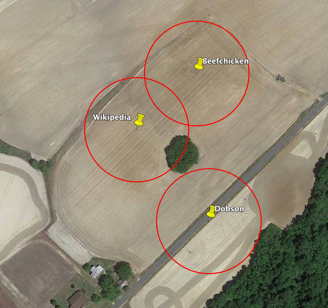
Wait, What About that Clump of Trees? Isn't that the spot?
According to Colonel Derek L. Duke, via Fred Dungan, the clump of trees is an overgrown cemetery.
Who's Right
The only way to know for sure would be to dig up the thing. The second best way to know would be to hire a surveyor. Without investing in a surveyor, and without having to convince the landowner that you need to be all up in his business, I think my solution is the best. Not because I'm special, but because unlike the anonymous Wikipedia commenter, I show my work.
Final Answer
35°29'37.07"N 77°51'30.56"W
Notes
The Wayne County GIS system (the first image)uses a projection (State Plane) that results in north not being straight up the further east or west you move from the central meridian.
Thanks to Fred Dungan for his extensive documentation of broken arrows, and the UNC-CH team for their research on the Goldsboro incident, including the full text of the deed.